Links:
Guadalupe River Park and Gardens:
Part 1: Central - Coleman Road to the Arena Green
Part 2: South - Santa Clara Street to I-280
Part 3: North - Guadalupe Gardens to I-880
The Guadalupe River Trail: I-880 to Hwy 101
The Guadalupe River Trail: Hwy 101 to Alviso
Los Alamitos Creek Trail
San Jose Parks
Guadalupe River Trail
Guadalupe Creek Trail
Bay Area Biking
Bay Trail
Bay Area Parks
Bay Area Back Pages
SF Bay Rec & Travel
Guadalupe River Park and Gardens
Part 3 North: Guadalupe Gardens to I-880
This
page covers the north part of the trail from the Guadalupe Gardens to
I-880. The Guadalupe Gardens are on the west bank of the river between
Coleman Avenue and Taylor Street.
The Guadalupe Gardens are under the flight path to
Mineta San Jose International Airport. That's one of the reasons why
there's a garden here and not homes. Over 630 homes were removed from
this area starting in 1975 because of airport noise and safety
concerns. The gardens
currently include the Courtyard Garden, Heritage Rose Garden, Historic
Orchard, and Taylor Street Rock Garden.

The
gardens are a good place for
plane-watching. Here, near the northwest corner of the park, is a field
of poppies and a small hill.

View of the Courtyard Garden

View of the Courtyard Garden in the foreground and the Heritage Rose Garden in the background

Courtyard Garden path lined by roses and irises.

Courtyard Garden

Courtyard Garden

Sunflowers at the Heritage Rose Garden

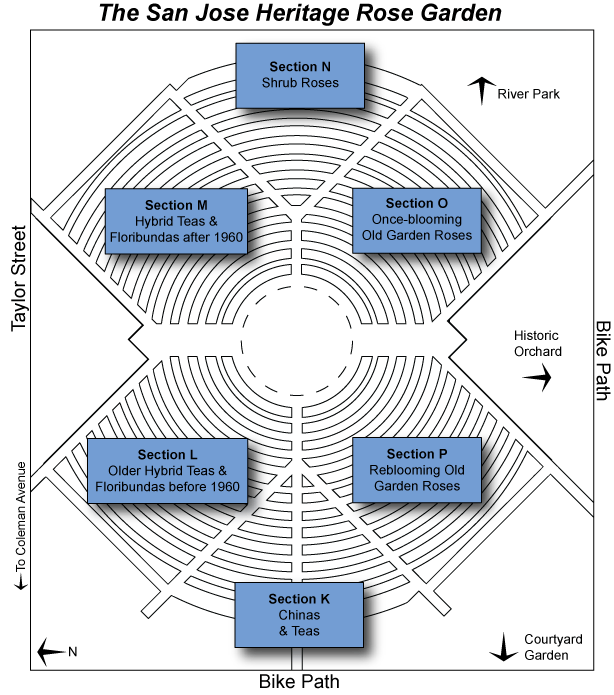
Heritage Rose Garden

Heritage Rose Garden


Historic orchard

The
Visitor & Education Center, located at 438 Coleman Avenue, is the
headquarters of the Friends
of Guadalupe River Park & Gardens. Meetings and Educational programs are
held here.

Pune,
India sister city monument

This
is the Guadalupe Gardens Taylor Street Demonstration Rock Garden, which
runs along the sidewalk for two blocks alond West Taylor Street, next
to Columbus Park. The purpose of the garden is to demonstrate
low-maintenance and water-efficient landscaping, using drought-tolerant
plants.
North
of Coleman, the character of the riverbed changes dramatically compared
to the sections to the south. Instead of the concrete river channel and
flood control culvert, the river here widens out, with gently-sloping
banks. During low flows, the river is confined to a narrow channel,
surrounded by vegetation, and with small dams. The vegetation along the
banks provides shade for the fish in the river.

Park and lawn north of the Taylor Street Bridge

South side of the West Taylor Street Bridge

North side of the West Taylor Street Bridge


Natural vegetation along the river

Trees lining the river trail

West Hedding Street Bridge

Near the end of the trail is a memorial bench and the Hwy 880 bridge.
The
trail goes under the I-880 bridge, then up to a levee road, paralleling
Airport Blvd. and Mineta San Jose International Airport. To see this
route, see the Guadalupe River Trail: I-880
to Hwy 101. To see the
trail north of 101, see the Guadalupe
River Trail: Hwy 101 to Alviso.
Created by Ronald Horii,
7/19/07, updated 1/20/08